Landscape Design: A Primer - Part 2
By Laurie Sheldon
 |
| Diagram of the Design Process, adapted from Simonds, John Ormsbee. Landscape Architecture – A Manual of Site Planning and Design. |
In my previous blog I listed the
series of steps, collectively known as the Design Process, which
Landscape Architects employ when designing outdoor spaces - regardless of
scale. This methodological approach to design enables the Landscape Architect
to clearly identify the optimal arrangement between the elements they hope to
incorporate into a landscape and its existing natural and constructed features.
It includes the following:
1. Statement of Intent
2. Procurement of a Topographic Survey
3. Site Inventory and Analysis
4. Program Development
5. Conceptual Diagramming
6. Diagram Selection
7. Master/Site Plan and Design
Development Documents
A brief recap of steps 1 & 2
1. Prepare of a Statement of Intent,
wherein you will determine the scope of your project and identify project goals
and objectives.
2. Obtain a topographic survey of your
site, which be the foundational layer of information upon which your design is
based, and can be obtained through various federal, state, and city/county
resources.
Now that I've caught you up to speed or
refreshed your memory, let's move on to Step 3: Site Inventory & Analysis.
 |
| A Topographic Survey of your Site (Step 2) will act as the "Base Map" for your Inventory & Analysis (Step 3) |
Site Analysis, on the other hand, is qualitative. It answers the question "So What?" as it relates to the inventory you've gathered. A comprehensive Site Analysis is an invaluable tool for determining the most and least suitable locations for the various elements and activities that you or your client hope to incorporate into your site (which are also referred to collectively as your “program”).
The lists below represent the categories and specific items that you should inventory, analyze, and map - to scale - on the Topographic Survey that you obtained in Step 2. A list of resources for researching these items is provided at the end of the article. We will refer to this as your "Base Map." If you are not comfortable preparing drawings with an engineer's scale, consider enlarging or reducing your Survey with a photocopy machine until you can get its graphical scale to register at 10' = 1". At that point you can copy it onto a sheet of graph paper so that measurements you gather outside will be much easier to translate into drawings. Use a pencil, PLEASE; we all make mistakes measuring at some point. If your notes are on top of one another or your drawings seem to be getting cluttered, don't hesitate to make several base maps - you can synthesize the inventory and analyses that inform your site design later on.
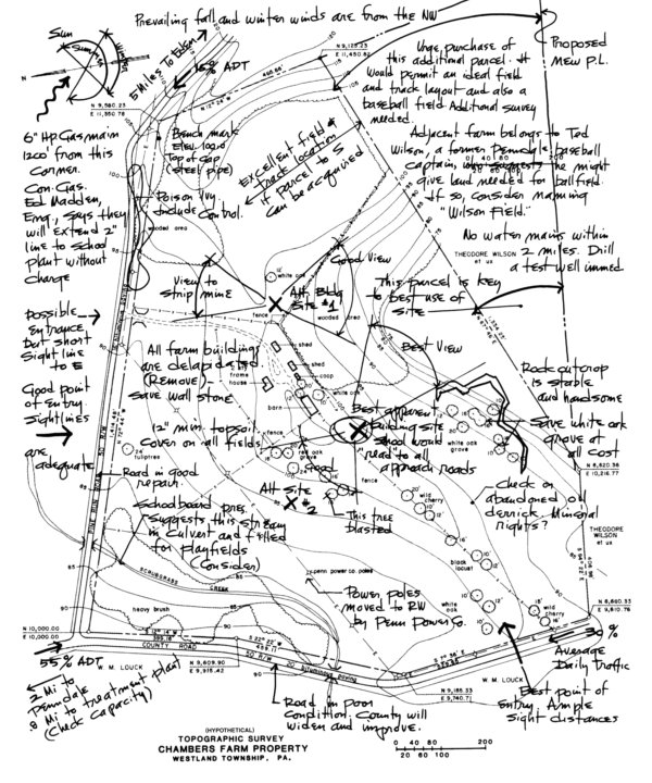 |
Analysis of the Topo Survey shown in the previous image |
- Climate: light, temperature (high and low averages), wind direction and intensity, moisture, annual precipitation, humidity, solar orientation (aspect) and their effects on human comfort. Any unusually hot, cold, windy, bright and/or dark spots (microclimates) should also be noted
- Topography: slope gradients, landforms, spot elevations, drainage patterns
- Soil: obtain a soil survey, which will provide detailed information about your soil’s genesis, classification(s), fertility, susceptibility to erosion, moisture content, pH, aeration/compaction, texture/gradation, organic content, and load bearing capacity
- Geologic features: bedrock type, depth to bedrock, underlying hazards like sinkholes and faults, visible rock outcroppings
- Hydrologic features: existing flood plains, rivers, lakes, marshes, streams, bogs, wetlands, watersheds, drainage patterns, water table depth, and underground springs. Note if any features are particularly outstanding or of poor quality.
- Vegetation: existing types or varieties, including data about their sizes, locations, shade patterns, aesthetic value, and importance to wildlife
- Existing wildlife: species and specific forage, habitat, water, and territorial needs
 |
| In addition to annotations, this Site Analysis uses color and graphic symbols to enhance its readability |
- Structural elements: buildings, fences, hardscaped areas
- Movement patterns: vehicular, pedestrian, and bicycle linkages on or near the site, major points of access and egress, mass transit
- Utilities: electric, gas, sewer/septic tank, telephone, cable, water, and storm drains, including depth or height of each and their condition
- Zoning and land use: current use of areas adjacent to the project site, zoning restrictions, property lines, easements, setbacks
- Codes and Regulations: deed restrictions, building/landscape codes, ordinances, covenants
- Historical features (if applicable): archeological sites; landmarks; building type, size, condition
- Social elements: population, intensity, distribution, age composition, educational level, income level, ethnic or type; economic and political factors; social configurations of the residents; usage of the area; other social factors affecting usage of the area. Quite simply, you are planning for a particular user group or groups. Once you know who your intended users are, you can tailor your design decisions to best suit their needs and taste.
- Spatial elements: views into and from the site; sequential relationships of existing spaces
Although this may seem like an inordinate amount of work, you must bear in mind that we cannot successfully design with nature if we negatively impact the environment. Through the process of Inventory and Analysis we justify where the most intensive development should occur, where the sensitive areas are that need protection, and what the site's outstanding features are that should probably be accentuated.
 |
| Analysis of aspect and users is the key to making these courts fun to play on |
- After calculating rise/run, you discover a large, open square area with a 1 degree slope. Your topographic analysis tells you this is just the spot for locating the two adjacent tennis courts your client has asked for, but which direction should they go? If you consider the aspect (directional) component (in the climate category), you will lay them out running north to south. Why? Because by doing so, you eliminate your users (social category) from having to look directly into the sun when playing on the court. Make sense?
- You decide that it's just not worth it to hire a Landscape Architect to give your home some "curb appeal," so you head over to the local big-box home improvement store, grab some annuals, shrubs, mulch, and couple of the guys hanging out in the parking lot looking for work. Once you return home, you instruct one of the men to dig holes for the shrubs. He picks up a shovel, plunges it into the ground, hits an electrical line and is badly injured. A proper inventory of the utility lines would have prevented this scene from happening... and an injured man on your front lawn has little "curb appeal."
I hope that you've enjoyed this installment of Landscape Design: A Primer, and will join me for Part 3, which will continue with Program Development - the fourth step in the Design Process.
Resources:
Florida Climate Center Data http://coaps.fsu.edu/climate_center/data.shtml
Florida Geological Survey, Data & Maps http://www.dep.state.fl.us/geology/gisdatamaps/index.htm
Florida Online Soil Survey Manuscripts http://soils.usda.gov/survey/online_surveys/florida/
Survey-related Data http://data.labins.org/2003/
Florida Utility Location http://www.callsunshine.com/
Municipal Codes & Ordinances http://www.municode.com/library/FL
Nat'l Register of Historic Places, Florida http://nationalregisterofhistoricplaces.com/fl/state.html
This blog is dedicated to the memory of my grandmother, Emilie Shaw, who was 98 years old when she passed away three days ago. In 1958, she selected a lot for building her Miami home based upon her inventory and analysis of its vegetation...specifically, its Live Oak trees, one of which, as she was told, was already over 100 years old. After seven category 3+ hurricanes, her tree remains the focal point of the street-facing side of her home.


Comments
Don't give up on becoming a Landscape Architect if that's what you are interested in. The more thorough a LA is, the less likely he/she will be to make decisions that negatively impact the environment. If your site is very small, you probably don't need to get crazy with background research, but it definitely can't hurt to check out some of the resources (like a soil survey or your city's landscape codes/ordinances) just to see what they're all about.
Sincerely,
Laurie